Source
Captured Post Date:
2026-02-28 11:15
Author:
factnameh
Translated Content:
This video is of the aftermath of the US and Israeli attacks on March 29, 1404, at 72 Narmak Square, on the corner of Hedayat Blvd. in Tehran.
We have verified this location. Tehran, Iran:
35°43'34.8"N 51°29'14.9"E
@GeoConfirmed
Content:
این ویدیو از آثار حملات آمریکا و اسرائيل در روز ۹ اسفند ۱۴۰۴، مربوط به میدان ۷۲ نارمک، نبش بنبست هدایت در تهران است.
We have verified this location. Tehran, Iran:
35°43'34.8"N 51°29'14.9"E
@GeoConfirmed
Images: 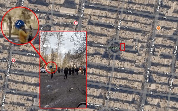
Additional Details
Captured Date
2026-03-09T12:50:49.000Z
Captured Post ID
2027714153293533437
Language
Persian