Incident Code
CS077
Incident Date
11 June 2015
Location
الموحسن, Al Muhassan, Deir Ezzor, Syria
Geolocation
35.2257487,
40.3109038
Accuracy: Village
Geolocation
35.2257487,
40.3109038
Accuracy: Village
Airwars Assessment
Last Updated: December 15, 2024
(Previous Incident Code: S076)
A lawyer and muezzin of the village mosque, died in an alleged Coalition strike which damaged the building according to reports.
The victim’s two brothers Juma’a and Saleh had also previously been killed during clashes with regime forces.
Key Information
Country
Military Actor
Civilian Harm Reported
Yes
Civilian Harm Status
Fair
Civilians reported killed
1
1 Man
Geolocation Notes
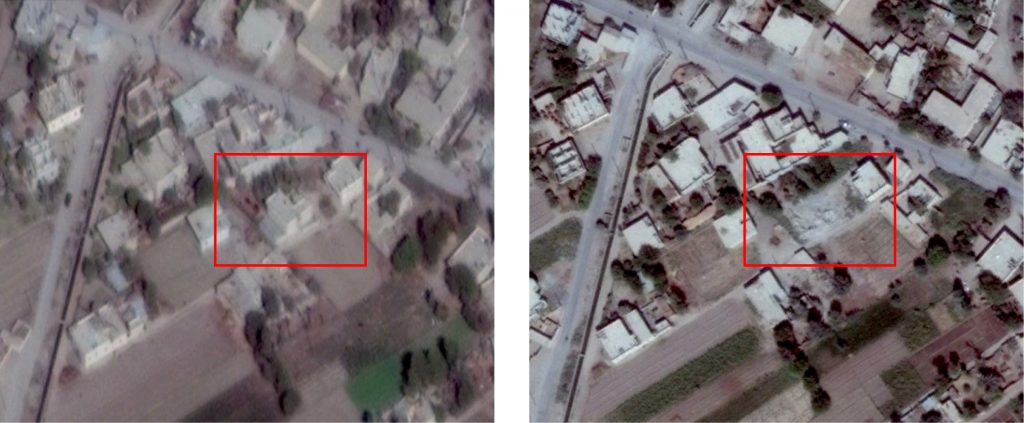
Reports of the incident mention the village of Muhassan (الموحسن), Deir Ezzor, for which the coordinates of its midpoint are: 35.2257487, 40.3109038. Based on satellite imagery in which structural damage can be seen (see below), a possible location of the incident is: 35.2107911, 40.3474268

Structural damage seen on satellite imagery (left: 11 November, 2014; right: 6 October, 2016)
Imagery: © 2018 Google
Military Statements
U.S.-led Coalition Assessment
Suspected belligerent
U.S.-led Coalition
U.S.-led Coalition position on incident
Non credible / Unsubstantiated
Reason for non-credible assessment
No Coalition strikes were conducted in the geographical area
Civilian deaths conceded
None
Civilian injuries conceded
None
Stated location
near Muhasan, Syria
Location accuracy
100 m
MGRS coordinate
37SFU192988
U.S.-led Coalition Strike Report
For June 10th-11th 2015, the Coalition reported that “Near Dayr Az Zawr, four airstrikes struck four ISIL crude oil collection points.”
U.S.-led Coalition Civilian Casualty Statement
2018-09-27
Original Source ↗
After a review of available information it was assessed that no Coalition strikes were conducted in the geographical area that correspond to the report of civilian casualties.
