Geolocation
Airwars assessment
Six civilians reportedly died and 11 were wounded in alleged Coalition airstrikes on Tabaqa, according to local media.
The Syrian Observatory for Human Rights reported that “warplanes believed to belong to the International Coalition bombed areas in the second and third neighborhoods of the town of Tabaqa in the western Rif Al Rigga. No casualties were reported.”
According to the Smart News Agency “A medical source said six bodies belonging to civilians and 11 wounded, including a woman and three children, arrived at the National Tabaqa Hospital.” A local source said that the raids targeted the First neighborhood, the Old Villas district and military housing near the ‘Mujahideen Affairs’ building of the Islamic State west of the city. The raids coincided with an attempt by the Syrian Democratic Forces to advance from the south and south-west of the city, as it approaches its eastern entrance.
The incident was first reported on April 17, 2017 at 1:30 pm by @ilham24877501.
Geolocation notes (1) [ collapse]
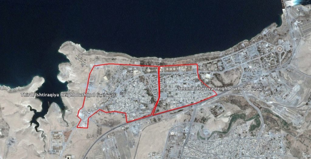
Reports of the incident mention the town of Tabaqa ( الثورة), Raqqa governorate, for which the coordinates are: 35.8295049, 38.5360909. The ‘second’ and ‘third’ neighbourhoods of Tabaqa are mentioned. The second neighbourhood respectively refers to the Hurriya (الحرية) or ‘Freedom’ neighbourhood, for which the coordinates are: 35.846667, 38.543889. The third neighbourhood refers to the Ishtiraqiya (الاشتراكية) or ‘Socialism’ neighbourhood, for which the coordinates are: 35.8454216, 38.5355544.
Summary
Sources (11) [ collapse]
Attached to this civilian harm incident is a provisional reconciliation of the Pentagon's declassified assessment of this civilian harm allegation, based on matching date and locational information.
The declassified documents were obtained by Azmat Khan and the New York Times through Freedom of Information requests and lawsuits filed since March 2017, and are included alongside the corresponding press release published by the Pentagon. Airwars is currently analysing the contents of each file, and will update our own assessments accordingly.
US-led Coalition Assessment:
Civilian casualty statements
-
The report contains insufficient information of the time, location and details to assess its credibility.
Original strike reports
For April 16th-17th, the Coalition reported: “Near Tabqah, five strikes engaged two ISIS tactical units and suppressed three ISIS tactical units.”
For April 17th-18th, the Coalition reported: “Near Tabqah, seven strikes [1 British] engaged five ISIS tactical units, destroyed three fighting positions and damaged six fighting positions.”
‘Monday 17 April – Typhoons struck a further target in Syria, south of Tabqah, and Tornados destroyed a heavy machine-gun in Rawah, western Iraq…On Monday 17 April, the Tornados operated over western Iraq, where a heavy machine-gun had been spotted, concealed within a grove of trees at Rawah. A single Paveway IV destroyed the weapon. Typhoons continued their support to the SDF west of Raqqah, and conducted a successful Paveway attack on a group of terrorists positioned in a treeline to the south of Tabqah.’