Civilian Casualties

Civilian Casualties

Incident Code

CI820

Incident date

August 1, 2017

Location

تل عفر, Tal Afar, Nineveh, Iraq

Geolocation

36.375659, 42.451536 Note: The accuracy of this location is to Town level. Continue to map

Airwars assessment

According to local sources said that civilians were killed or injured in alleged Coalition and Iraqi force airstrikes on Tal Afar city, west of Mosul.

Tal Afar news agency reported that the aerial bombardment has continued in Tal Afar for the third day in a row. Civilians were confirmed dead, and the source said that Coalition aircraft bombed IS sites and the streets of the city intensively. Madar Al Arab reported that the commander of Nineveh operations confirmed the continued bombing of Tal Afar by the government and international Coalition aircraft.

Ali Alazawi added that the bombing led to the killing of the so-called training camp officials of IS.

The incident was first reported on August 1, 2017 at 12:13 am by وكالة انباء تلعفر Tal afar.

Summary

  • Civilian harm reported
    Yes
  • Civilians reported killed
    2
  • Civilians reported injured
    2
  • Airwars civilian harm grading
    Contested
    Competing claims of responsibility e.g. multiple belligerents, or casualties also attributed to ground forces.
  • Suspected attackers
    US-led Coalition, Iraq Government Forces

Sources (4) [ collapse]

Geolocation notes (2) [ collapse]

Reports of the incident mention a number of locations within the city of Al-Tal Afar (تلعفر): Al-Sadiq al-Ameen Preparatory (إعدادية الصادق الأمين), which Airwars was unable to locate, however the location for Al-Tal Afar Preparatory School (إعدادية تلعفر) can be seen below; Al-Nada neighbourhood (حي النداء); the Al-Adli mill (طاحونة العدلي), which Airwars was unable to locate, for a possible location see below, and the village of Al-Alu (قرية العلو). Satellite imagery available to Airwars of July 27, 2017 and August 4, 2017 (a 13 day window) shows structural damage at the location of the Al-Tal Afar Preparatory school (إعدادية تلعفر), for which the coordinates are: 36.378889, 42.462778

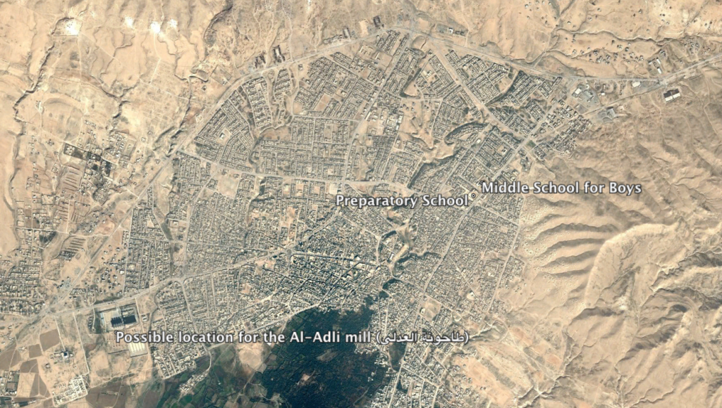
  • Possible location for the Al-Adli mill (طاحونة العدلي), the Al-Tal Afar Preparatory School (إعدادية تلعفر) and the Tal Afar Middle School for Boys and Secondary Dhi Qar Evening (متوسطة تلعفر للبنين وثانوية ذي قار المسائية)

    Imagery:
    © 2018 Google

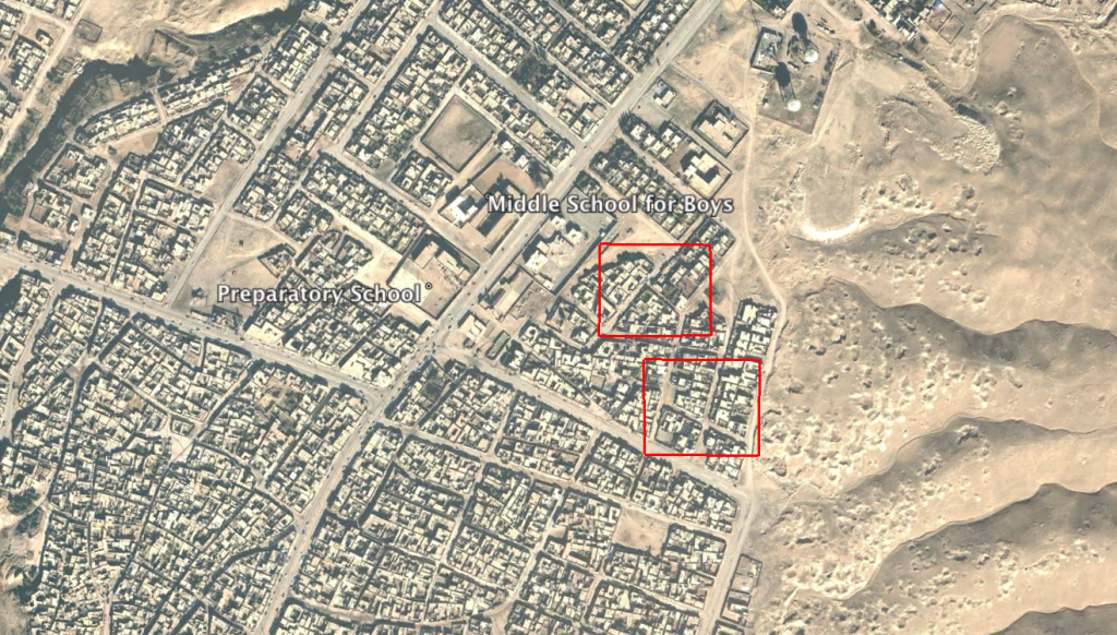
  • Locations of structural damage seen on satellite imagery available to Airwars of August 4, 2017

    Imagery:
    © 2018 Google

US-led Coalition Assessment:

  • Suspected belligerent
    US-led Coalition
  • US-led Coalition position on incident
    Non credible / Unsubstantiated
    Insufficient information to assess that, more likely than not, a Coalition strike resulted in civilian casualties.
  • Reason for non-credible assessment
    Insufficient information on the time and location
  • Civilian deaths conceded
    None
  • Civilian injuries conceded
    None
  • Stated location
    near Tel Afar, Iraq
    Nearest population center
  • Location accuracy
    100 m
  • MGRS coordinate
    38SKF711280
    Military Grid Reference System

Civilian casualty statements

US-led Coalition
  • May 31, 2018
  • The report contains insufficient information of the time, location and details to assess its credibility.

Original strike reports

US-led Coalition

For July 31st – August 1st , the Coalition reported: “Near Tal Afar, one strike engaged an ISIS tactical unit and destroyed four fighting positions and two supply caches.”

Iraq Government Forces Assessment:

  • Suspected belligerent
    Iraq Government Forces
  • Iraq Government Forces position on incident
    Not yet assessed

Summary

  • Civilian harm reported
    Yes
  • Civilians reported killed
    2
  • Civilians reported injured
    2
  • Airwars civilian harm grading
    Contested
    Competing claims of responsibility e.g. multiple belligerents, or casualties also attributed to ground forces.
  • Suspected attackers
    US-led Coalition, Iraq Government Forces

Sources (4) [ collapse]