Incident Code
Incident Date
Location
Geolocation
Geolocation
Airwars Assessment
(Previous Incident Code: S60)
Sources reported that five unnamed civilian were killed – along with fighters with the al-Nusra Front – in an airstrike on the Syria-Turkey border town of Atama. The building targeted was described as the local headquarters of the al-Nusra Front, an al Qaeda linked faction occasionally targeted by US forces.
Photographs and videos depicted heavy airstrikes within the town, which is also in near proximity to a camp for internally displaced peoples (IDPs.).
According to Siraj, six non-combatants died in the attack, which “completely destroyed a number of houses, and caused material damage in others. The hospital in Atma also sustained minor damage, in the area west of Afrin majority inhabited by Syrian Kurds.”
Hawa cited local residents as saying that following the attack, “elements from Al Nusra Front surrounded the scene of the bombing and prevented civilians from approaching, along with the closure of many shops in the town to its doors after the bombing.”
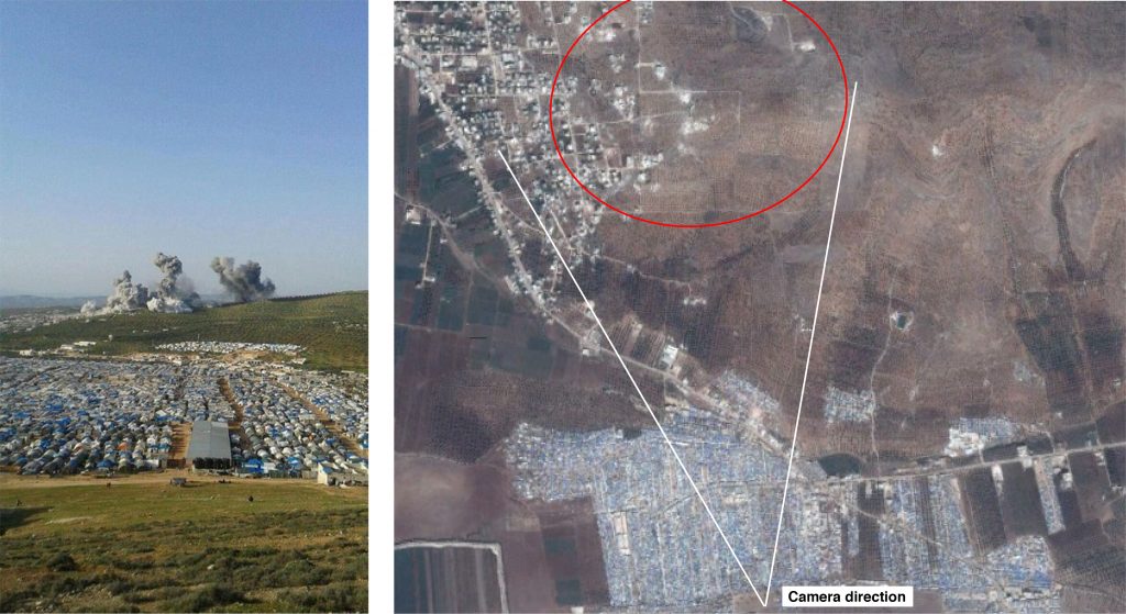
A later assessment by Forensic Architecture used imagery analysis to identify the location of three airstrikes at Atama, concluding that the attack took place 900m from the nearby IDP camp. As a summary noted, “The case uses clips found in social media websites online to investigate three air strikes on 8 March 2015, near the town of Atimah in Syria and the displaced persons camp of the same name, both abutting the Northern border to Turkey. Shortly after the strikes, several people recorded the incident and uploaded their videos and images online, both on Youtube and Twitter. The case was reported by Airwars who provided Forensic Architecture with the primary analysis and narrative. The Forensic Architecture team identified the location of the strikes close to homes and a public building, and only 900m from the edge of the camp where more than 30,000 people are sheltered. No nation has so far claimed responsibility for this attack, though the target seems to be al Qaeda militants, that operated in the area. The strike reportedly killed six civilians”
Key Information
Geolocation Notes
Reports of the incident mention Atimah village ( اطمه ), Idlib Governorate, for which the coordinates are: 36.3093144, 36.6781997. Film and photographic evidence suggest that the airstrike was focused on the South East area of the village

Position of camera (marked on satellite image taken in October 2015) showing the location of the airstrike in the South East of Atimah (اطمه) in red
Imagery: © 2015 TurkPress © 2018 Google
