Incident Code
Incident Date
Location
Geolocation
Geolocation
Airwars Assessment
(Previous Incident Code: S1190)
Multiple local sources reported that there had been an “escalation of civilian martyrs” following alleged artillery shelling on the Na’im area of Raqqa. This was later confirmed to have been a US airstrike.
Raqqa News Post for example reported at the time: “#Urgent : # Ar Raqqa The fall of artillery shells on the area of Naim and Tal Abyad Street and Al Salam hospital by the Kurdish units.”
While there were reports of “an escalation of civilian martyrs” no specific casualty numbers were reported.
In its civilian casualty report for November 2019 – published on January 2nd 2020 – the Coalition conceded one death and one injury in this event, noting: “August 11, 2017, in Raqqah, Syria, via Airwars report. Coalition aircraft conducted an airstrike against a Daesh vehicle. Regrettably, one civilian was unintentionally killed and one civilian was unintentionally wounded as a result of the strike. 2074/S1190 37SEV009787”.
In May 2020, in its annual civilian harm report to Congress, the Pentagon declared this to have been a US military action.
Key Information
Geolocation Notes
Reports of the incident mention several areas in the city of Raqqa: the area around the Na’im (ﻣﻨﻄﻘﺔ ﺍﻟﻨﻌﻴﻢ) roundabout, for which the coordinates are: 35.95447, 39.009392; Tal Abyad street (ﺷﺎﺭﻉ ﺗﻞ ﺃﺑﻴﺾ), for which the coordinates are: 35.948534, 39.012615; and Al Salam hospital (مشفى السلام), for which the location is unknown to Airwars. Prior to the Coalition releasing the MGRS for this incident, Airwars had geolocated it to the nearest neighbourhood/area at 35.95447, 39.009392.
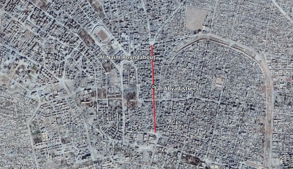
Na'im (ﻣﻨﻄﻘﺔ ﺍﻟﻨﻌﻴﻢ) roundabout and Tal Abyad street (ﺷﺎﺭﻉ ﺗﻞ ﺃﺑﻴﺾ) in the city of Raqqa
Imagery: © 2018 Google