Incident Code
Incident Date
Location
Geolocation
Geolocation
Airwars Assessment
(Previous Incident Code: S1215 )
In a major civilian casualty event, between 23 and 50 civilians were reported killed and dozens injured in the Bedo neighborhood of Raqqa, local media reported.
However, in May 2019 the Coalition announced that it had classed the civilian harm allegations as non-credible, noting “after a review of all available strike records it was determined that, more likely than not, civilian casualties did not occur as a result of a Coalition strike.”
In the main, sources estimate the death toll at “more than 40”. However, a Tweet by @Q_Alenezy suggested that there could be “more than 50” dead, as people were still trapped under rubble.
The incident was described by some sources, including Step News Agency, as “one of the largest massacres since the start of the battle”. Nearly all sources tracked held the US-led Coalition responsible for the airstrikes and the subsequent loss of civilian life.
The Syrian Network for Human Rights put the death toll at 23. However, most other sources said that up to 40 civilians had died – mostly women and children. Sound and Picture said that 42 had been killed.
Activists that spoke to Smart News said “the bombing targeted a residential building in the Bedu neighbourhood, near Na’im roundabout, which the organization used as a platform for executions, and that bodies were still under the rubble”. The death toll, sources said, is likely to rise due to the people still trapped under the destroyed buildings.
Local residents were able to save three people who were next to the building, according to a correspondent cited in Sound and Picture.
The Euphrates Post published a series of photographs of the homes destroyed; the houses of Musa al Mashhadani, Khalil al-Mahbash and Fadel Moussa and Darda.
Geolocation Notes
Reports of the incident mention multiple locations around the Al Naim roundabout (دوار النعيم), for which the coordinates are: 35.95447, 39.009392. The video posted by Euphrates Post shows damage to buildings at the following coordinates: 35.957969, 39.007720.
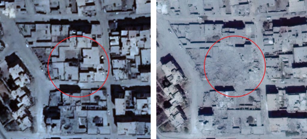
Damage to a building in the Badou neighbourhood (left: August 19, 2017; right: August 25, 2017)
Imagery: © 2019 Google

Reports of the incident mention the neighbourhood of Al Badou (البدو)
Imagery: © 2019 Google