Incident Code
Incident Date
Location
Geolocation
Geolocation
Airwars Assessment
(Previous Incident Code: S1225 )
A major civilian casualty event in which 40 to 50 or more people reportedly died, and between 60 and 100 people injured, followed US-led Coalition airstrikes in conjunction with artillery shelling, alleged local sources.
The offensive targeted the Malahi (Amusement Park) district of Raqqa City and obliterated a four-storey residential building, where more than 40 civilians were said to be inside. Raqqa is Being Slaughtered Silently, amongst others, said that seven entire families were victims of the attack. Sources described a “crusade of coalition aircraft and artillery #SDF”. Airwars understands that only the Coalition have access to artillery in Raqqa.
Subsequent reports labelled the incident a “horrific massacre” in which “mostly women and children” were killed. Both Smart and Micro News did not mention the US-led Coalition explicitly, but referred to “warplanes” and “artillery” that targeted residential buildings in a collaborative operation. All other sources cited the US-led Coalition directly.
In their first assessment of this event in October 2017, the Coalition deemed this event non-credible, reporting that “The report contains insufficient information of the time, location and details to assess its credibility.” In their second assessment in March 2022, the Coalition kept this even classified as non-credible, with the reasoning that “After review of all available evidence it was determined that more likely than not civilian casualties did not occur as a result of a Coalition strike.”
Geolocation Notes
Reports of the incident mention a four-storey residential building next to the Amusement Park (حديقة الملاهي) in the city of Raqqah. Airwars geolocated the image shared by RBSS of this building to these exact coordinates: 35.958095, 39.006309. Damage to this building can be seen on satellite imagery between August 21 and 25, 2017. Coordinates released by the Coalition place the event at 35.95808, 39.00630
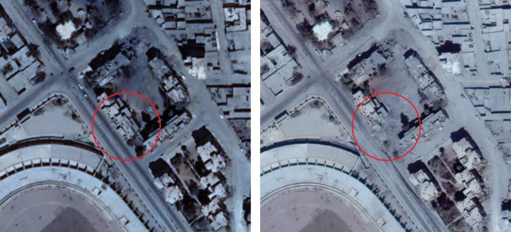
Damage seen on satellite imagery to the building in the image shared by RBSS (left: August 19, 2017; right: August 25, 2017)
Imagery: © 2019 Google