Incident Code
Incident Date
Location
Geolocation
Geolocation
Airwars Assessment
(Previous Incident Code: S1289 )
Two to four civilians were reportedly killed in Coalition air or artillery strikes on the al Jumaili neighbourhood of Raqqa City. There was some conflict of information regarding the culprit, though most sources blamed the US-led Coalition.
Sources that did not mention the Coalition referred to “artillery shelling” and “airstrikes”. Airwars understands that only the Coalition have access to artillery in Raqqa.
According to Diralzour and Raqqa Documentation and Legal Network, two of the victims named were situated inside their home when the house was hit by airstrikes. Raqqa is Being Slaughtered also named an additional civilian male.
Victims
Individuals
Geolocation Notes
Reports of the incident mention the neighbourhood of Jumaili (الجمیلي), for which the coordinates are: 35.957956, 39.002033. Satellite imagery shows the destruction of a building in that area between 6 and 19 September, 2017, for which the coordinates are: 35.958282, 39.000639.
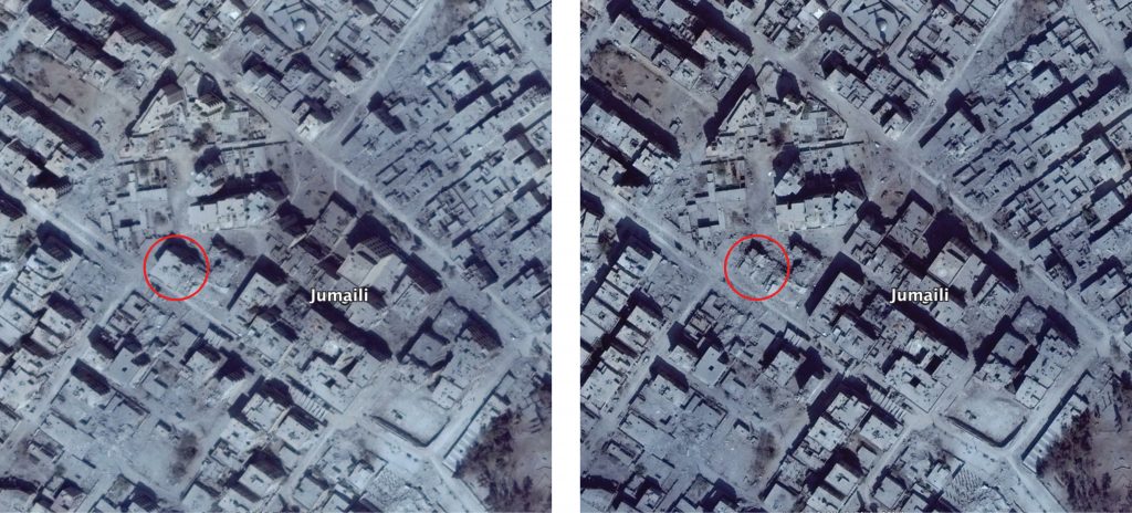
Structural damage seen in the neighbourhood of Jumaili (الجمیلي) (left: September 6, 2017; right: September 19, 2017)
Imagery: © 2018 Google