Civilian Casualties

Civilian Casualties

Incident Code

CS720

Incident date

April 23, 2017

Location

الحي الثاني, Tabaqa, Second Neighbourhood, Ar Raqqah, Syria

Geolocation

35.846667, 38.543889 Note: The accuracy of this location is to Neighbourhood/area level. Continue to map

Airwars assessment

Between three and eight civilians died including up to five children in alleged Coalition airstrikes on Tabaqa’s Al Thani neighbourhood, according to local media.

Smart News reported that a likely Coalition airstrike “targeted a house near the public park in the Second neighbourhood, killing a man, his wife and child. They also carried out raids on the roundabout of Al-Alam and the Third district, in addition to shelling the village of Ayed al-Saghir west of the city.”

Step News reported Coalition strikes in Tabaqa but made no initial mention of civilian casualties. It later reported that “a number” of people had died and were injured as the result of “Coalition aircraft and artillery”.

According to Syria Mirror, three civilians including one child died in a Coalition raid. Other sources also reported Coalition strikes in Tabaqa, though didn’t specify exact locations.

The incident was first reported on April 23, 2017 at 10:35 am by Alalam.

Summary

  • Civilian harm reported
    Yes
  • Civilians reported killed
    3 – 8
  • (1–5 children)
  • Civilians reported injured
    1
  • Airwars civilian harm grading
    Fair
    Reported by two or more credible sources, with likely or confirmed near actions by a belligerent.
  • Suspected attacker
    US-led Coalition

Sources (8) [ collapse]

Geolocation notes (2) [ collapse]

Smart News reported that a likely Coalition airstrike “targeted a house near the public park in the Second neighbourhood” The coordinates for Al Thani neighbourhood (الحي الثاني) are 35.846667, 38.543889. Satellite imagery shows visible structural damage to residential buildings on the perimeter of Wahdah Public Park, between 23 Mar – 17 June 2017 (marked with a black cross). This is a possible location for the civilian casualty incident, however, due to the limited satellite imagery available to Airwars the analysis is inconclusive. During the 86 day period between available images, widespread destruction is visible elsewhere in Al Thani, making it is impossible to isolate the event.

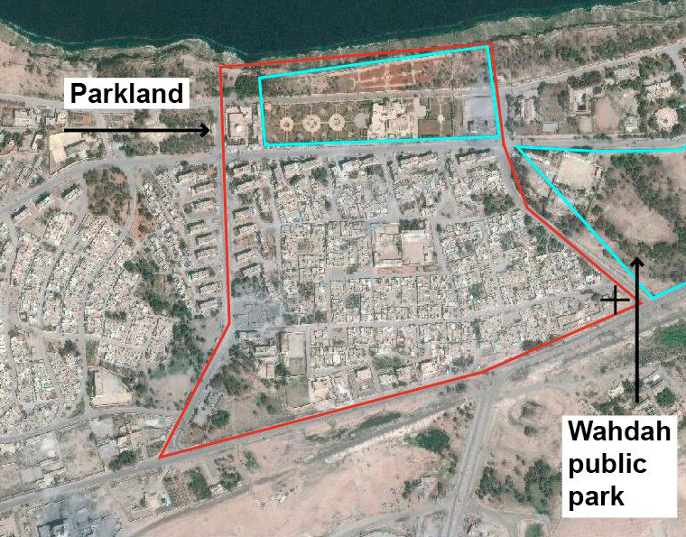
  • Before. The boundary of Al Thani neighbourhood ( الحي الثاني ) in red, with parkland marked in blue. The coordinates for the destroyed residential area are marked with a black cross.

    Date taken:
    March 23, 2019

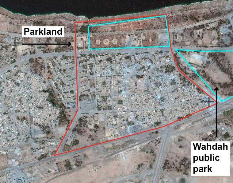
  • After. The boundary of Al Thani neighbourhood ( الحي الثاني ) in red, with parkland marked in blue. The coordinates for the destroyed residential area are marked with a black cross.

    Date taken:
    June 17, 2017

CJTF–OIR Declassified Assessment and Press Release

Attached to this civilian harm incident is a provisional reconciliation of the Pentagon's declassified assessment of this civilian harm allegation, based on matching date and locational information.

The declassified documents were obtained by Azmat Khan and the New York Times through Freedom of Information requests and lawsuits filed since March 2017, and are included alongside the corresponding press release published by the Pentagon. Airwars is currently analysing the contents of each file, and will update our own assessments accordingly.

Declassified Assessment Press Release

US-led Coalition Assessment:

  • Suspected belligerent
    US-led Coalition
  • US-led Coalition position on incident
    Non credible / Unsubstantiated
    Insufficient information to assess that, more likely than not, a Coalition strike resulted in civilian casualties.
  • Reason for non-credible assessment
    Insufficient information on the time and location
  • Civilian deaths conceded
    None
  • Civilian injuries conceded
    None
  • Stated location
    near Al Thani, Syria
    Nearest population center

Civilian casualty statements

US-led Coalition
  • Jan 25, 2018
  • The report contains insufficient information of the time, location and details to assess its credibility.

Original strike reports

US-led Coalition

For April 22nd-23rd, the Coalition reported: “Near Tabqah, eight strikes engaged six ISIS tactical units and destroyed five fighting positions and two IEDs.”

For April 23rd-24th, the Coalition reported: “Near Tabqah, 12 strikes engaged 10 ISIS tactical units and destroyed 12 fighting positions, one tactical vehicle, one ISIS vehicle, one heavy machine gun, and a command and control node.”

UK Military
  • English
    /
    Original

‘Sunday 23 April – Typhoons destroyed an armed truck south-west of Tabqah in Syria, while Tornados bombed a Daesh position in western Mosul…On Sunday 23 April, Typhoons assisted the SDF, destroying an armed truck near Tabqah, west of Raqqa. In western Mosul, a Daesh-held building was struck by a Paveway IV, released by a Tornado flight, after Iraqi troops came under fire from the building.’

Summary

  • Civilian harm reported
    Yes
  • Civilians reported killed
    3 – 8
  • (1–5 children)
  • Civilians reported injured
    1
  • Airwars civilian harm grading
    Fair
    Reported by two or more credible sources, with likely or confirmed near actions by a belligerent.
  • Suspected attacker
    US-led Coalition

Sources (8) [ collapse]