Incident Code
Incident Date
Location
Geolocation
Geolocation
Airwars Assessment
(Previous Incident Code: S1292)
Between 15 and 21 civilians died and 50 others were injured following an aerial offensive by the US-led Coalition, according to local media.
Step New Agency reported that the Coalition had carried out a raid on Al Badou neighbourhood, north of the Al Ma’ri school, which resulted in civilians killed and injured. The death toll was put at 21 civilians with 50 others wounded by Raqqa Post, following airstrikes on neighbourhoods held by so-called Islamic State. Raqqa Post also alleged the area “was subjected to artillery shelling from SDF” throughout the day.
Breaking News reported a lower toll of “15 martyrs” following “US bombing on the old neighbourhoods of Raqqa, and the vicinity of the hospital”.
The house of El-Anoot in Al Badou neighbourhood was “completely destroyed” according to @Q_Alenzy, who said the building was being used as a weapon factory by ISIS. In a subsequent tweet by @Q_Alenzy it was reported that two houses of the A’idan family were destroyed, in addition to several other houses.
At present it is unclear as to whether the 15 – 21 alleged dead in this incident were all in the vicinity of Al Badou or located in various neighbourhoods. @24raqqa documented at least 111 civilians killed “in the past three days” in besieged neighbourhoods. Breaking News also said irt was proving impossible to know “the size of the civilian casualties, because of the inability to lift the rubble to discover the fate of those under it, because of the intensity of the fire between the parties to the conflict in the city of Raqqa”.
Key Information
Geolocation Notes
Reports of the incident mention that the alleged Coalition airstrike targeted multiple neighbourhoods in the city of Raqqa (الرقة): the neighbourhood of Al Badou (البدو), the Tel Abyad (تل أبیض) street area, the National Hospital, Tawasu’iya (التوسعیة), Jumaili (الجمیلي), the station (المحطة), Rumaila (الرمیلة), Amassi street (الأماسي) and Andalusia (الأندلس). These areas were under IS control at that time. In the neighbourhood of Al Badou (البدو) a number of locations are mentioned: the house of El Anoot (العنطوط), which was used as an IS weapons factory; several houses including two houses of the A’idan family (العیدان); and the area north of the Al Ma’ri school (المعري). The coordinates for the Al Ma’ri school (المعري) are: 35.962029, 39.009908. On satellite imagery of 6 and 19 September structural damage to a building (35.964152, 39.009216) north of the Al Ma’ri school is visible, as well as lighter damage to a building (35.963084, 39.008358) northwest of the school around the same time
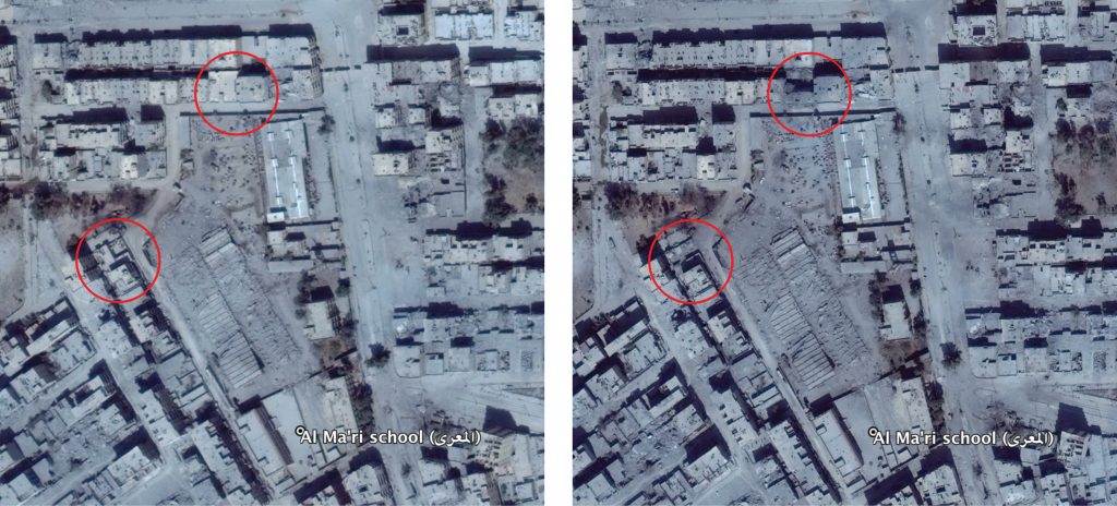
Structural damage seen north and northwest of the Al Ma'ri (المعري) school (left: 6 September, 2017; right: 19 September, 2017)
Imagery: © 2018 Google