Conflict

Israel and Gaza

Incident Code

ISPT0153

Location

محيط الكلية الجامعية للعلوم التطبيقية, Vicinity of the University College of Applied Sciences, Gaza, Palestinian territories

Geolocation

31.498788, 34.436807
Accuracy: Exact location (via Airwars)

Airwars Assessment

Last Updated: July 23, 2025

During the evening of Thursday October 12th, 2023, six civilians were reportedly killed and others wounded as a result of an alleged Israeli airstrike on a house located near the University College of Applied Sciences in the Tel Al-Hawa neighborhood, west of Gaza City, in the Gaza Strip. A Facebook post by Dcdgovps included photos of the Palestinian Civil Defense crews working amidst the rubble from the destroyed building.

The Facebook accounts of Made in Gaza and AlQahera News reported about injured civilians but did not provide a specific figure. Names or identities of the six killed victims were not revealed in the local sources either.

Where sources identified a belligerent, they attributed the strike to Israeli forces.

Assessment Updates

23 July 2025
Updated to include time of incident.

Key Information

Military Actor
Strike Type
Airstrike
Strike Status
Likely strike
Civilian Harm Reported
Yes
Civilian Harm Status
Fair
Causes of Death / Injury
Heavy weapons and explosive munitions
Civilians reported killed
6
Civilians reported injured
2

Geolocation Notes

Reports of the incident mention the vicinity of the University College of Applied Sciences (الكلية الجامعية للعلوم التطبيقية) west of Gaza city (غَزَّة). Analysing audio-visual material from sources, we have narrowed the location down to the following exact coordinates: 31.498788, 34.436807.

{"type":"FeatureCollection","features":[{"type":"Feature","properties":{"label":"Exact Location","label-type":"black-white"},"geometry":{"coordinates":[34.436807,31.498788],"type":"Point"}},{"type":"Feature","properties":{"label":"A","label-type":"white-red","stroke":"#ff0000","stroke-width":1,"stroke-opacity":1,"fill-opacity":0},"geometry":{"coordinates":[[[34.43697011727997,31.498810668937082],[34.43682768362018,31.498669219722444],[34.436894711224966,31.498604924554087],[34.437055577475604,31.49874351630656],[34.43697011727997,31.498810668937082]]],"type":"Polygon"}},{"type":"Feature","properties":{"label":"B","label-type":"white-red","stroke":"#ff0000","stroke-width":1,"stroke-opacity":1,"fill-opacity":0},"geometry":{"coordinates":[[[34.436599267154435,31.49835823958327],[34.43683111172089,31.498566192081228],[34.43659023424925,31.49877157681138],[34.43656614650283,31.498751038358478],[34.436560124566626,31.498781846035797],[34.43648786132556,31.498786980647935],[34.43648485035652,31.498769009504585],[34.43631322515887,31.498609836374328],[34.43636140065354,31.498555922833148],[34.436334301938075,31.49852511508135],[34.436599267154435,31.49835823958327]]],"type":"Polygon"}}]}

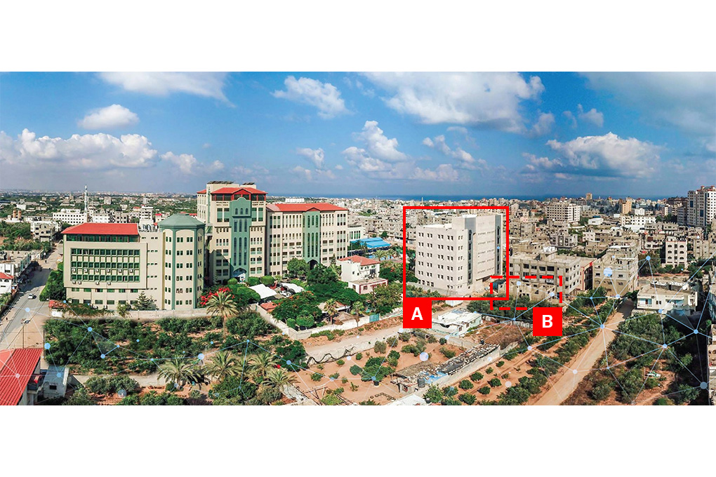
Imagery: Planning & External Relations Office - UCAS

Media From Sources (12)