Tracking civilians killed in Gaza’s designated ‘safe zones’ and how supposed havens became sites of fatal strikes
Airwars’ investigator Sanjana Varghese spoke to NPR’s Ruth Sherlock about this investigation. You can read the article here.
On October 12th, the Israeli military issued a blanket call for all Palestinians living in the north of the Gaza strip to move south, saying it was “for your own safety”. More than one million people were told to flee, ahead of an expected ground invasion.
The evacuation zone started at Wadi Gaza, which runs through the centre of the Gaza Strip. In theory, civilians fleeing south of that line should have been safer, but Palestinians have reported extensive attacks in civilian areas in the central and southern parts of Gaza.
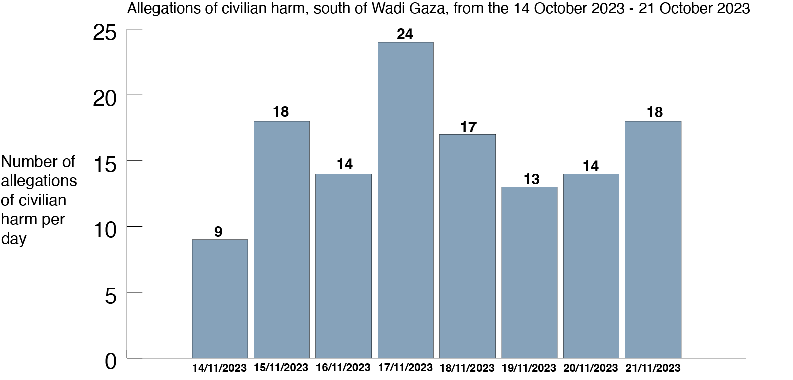
In the first seven days after the warning – from October 14th to 21st – Airwars’ investigation team tracked and geolocated at least 127 separate allegations of civilian harm from explosive weapons in this southern zone.
Amongst these strikes were many that allegedly hit densely populated neighbourhoods and civilian objects such as schools, hospitals and restaurants. The frequency of these allegations in this supposed safe zone suggests that there was no safe place for civilians in Gaza, despite assurances from Israeli authorities.
Safe to flee?
On October 7th, 2023 Hamas militants broke through the fence that separates Gaza from Israel and killed more than 1,000 people, according to Israeli authorities. In retaliation Israel has dropped thousands of bombs on Gaza ahead of a ground invasion, killing more than 10,000 people, according to Palestinian authorities.
Since October 7th, Airwars’ research team has been tracking every public allegation of civilian harm in order to provide an independent assessment of civilian casualties.
We have already tracked more than 1,000 separate allegations across the Gaza Strip alone; each allegation represents the death or injury of at least one civilian resulting from explosive weapons use. For the most part, these allegations are still being fully assessed by our research team – with additional sources identified, casualty ranges produced, and where possible details on civilian names and biographies captured. You can find full details of the around 40 published incidents here, and more about our methodology here.
But we have also been able to use these allegations to understand overall patterns of harm. By geolocating each harm claim from the week following the IDF’s instructions for civilians to move south, we have been able to pull together a comprehensive database of 127 likely Israeli strikes leading to allegations of civilian harm that occurred the week following the evacuation order. An allegation of civilian harm does not mean that just one civilian was injured or killed; these allegations often involve multiple people, as well as damage to buildings or family homes.
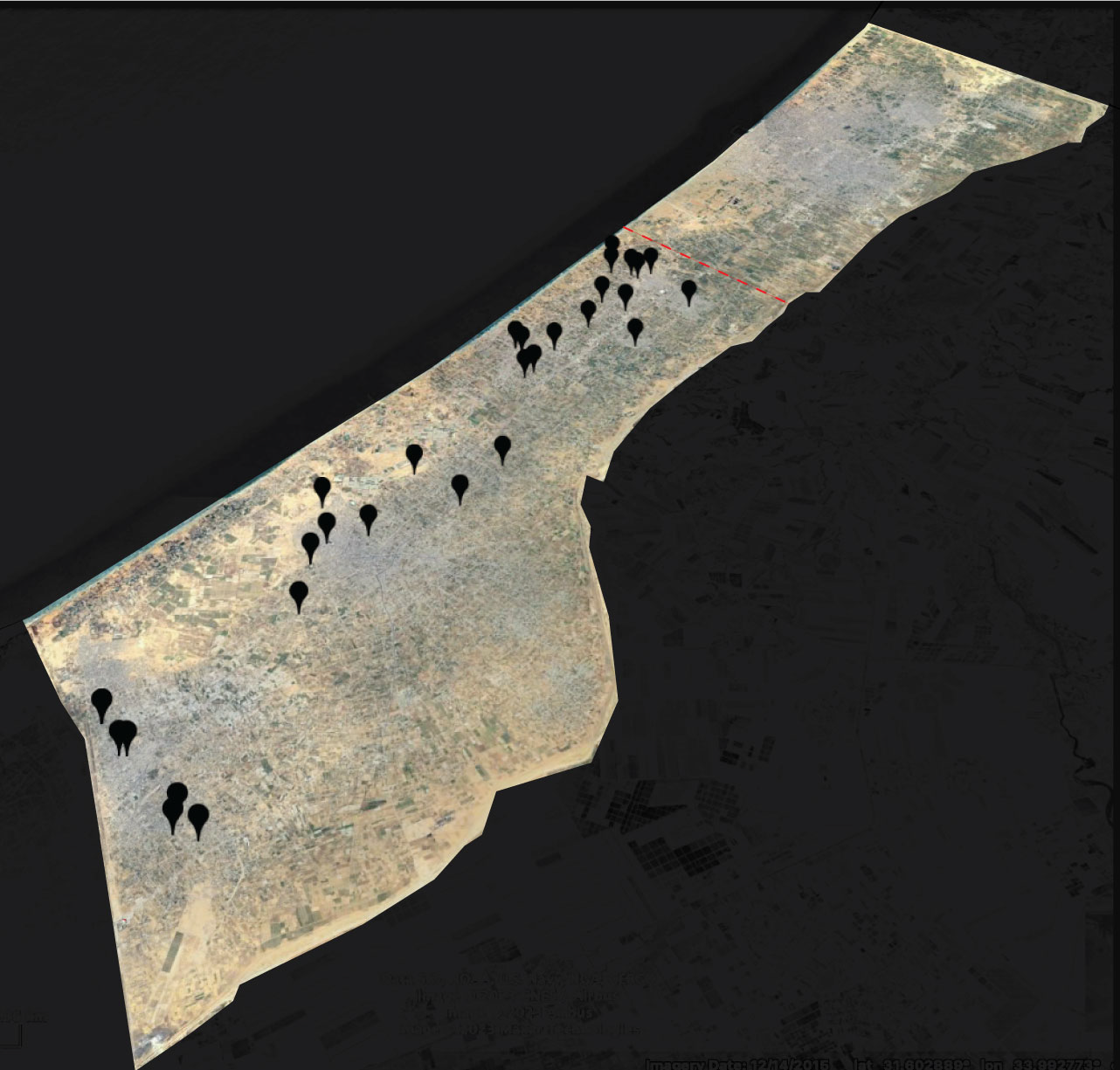
Map of civilian harm allegations, south of Wadi Gaza, between 14-21 October 2023. The red dotted line refers to the Wadi Gaza. Many locations include more than one alleged civilian harm incident. Sanjana Varghese / Airwars. Images via Maxar Technologies / Airbus / Google Earth.
We relied on news reporting, humanitarian agencies and organisations, open source documentation and relevant footage where necessary. We geolocated allegations to six levels of accuracy: area/region, neighbourhood, landmark/building, hospital, street, and an exact location. Any alleged civilian harm incident that we couldn’t geolocate was discounted from our dataset.
The distance from the Wadi Gaza to the Rafah Border Crossing on the southern border of the Gaza strip is roughly 27 kilometres. From east to west across the Gaza strip, the distance is around 6 kilometres at the narrowest point, and 12 kilometres at its widest point.
We found harm allegations on every day following the evacuation order. Just four days after the south was declared to be a safe area, the most civilian harm allegations were documented: twenty four allegations, suggesting at least twenty strikes in an area little longer than Manhattan.
In incidents that have been fully researched by Airwars’ research team, we found that in some cases strikes affected whole families as they sheltered together. In one incident, on October 21st, 2023, an alleged Israeli strike hit a Palestinian civil defence facility, alongside the Dahir family home, in Khirbet-al-adas, Rafah. Between six and ten people were likely killed in this strike and up to 11 injured. Of those killed, at least five were children from the same family, all aged 13 and under. Airwars assessors were able to cross-reference six of the individuals in this assessment with the dataset of names and individual ID numbers released by the Palestinian Ministry of Health (MoH).
In another incident on October 15th, in the al-Geneina neighbourhood in Rafah, the home of a doctor, Dr. Salah al-Din Zanoun, was hit. There were likely seven to eight people killed, all of whom were from the same family. Of those killed, Airwars assessors were able to cross-reference five of the individuals in this assessment with the dataset of names and individual health ID numbers released by the MoH.
We also found that multiple civilian objects – such as hospitals and schools – were hit in the south of Gaza. As people were told to move south – and around 700,000 people, according to the New York Times, did so initially – many took shelter in buildings such as hospitals and schools. In a number of cases large numbers of civilians were crowded together when strikes hit this infrastructure, such as a strike on a UNRWA school in al-Maghazi refugee camp, on October 17th. UNRWA said that around 4,000 people were sheltering at this school. The next day, an alleged airstrike hit another UNRWA school in Khan Younis – footage from the immediate aftermath clearly showed that groups of people had been using the school as a home, with clothes laid out over external railings around the school.
The scale of this campaign in Gaza makes this one of the most intense conflicts that Airwars has ever monitored – in just the first three weeks of the war, we monitored more individual incidents of harm than in any given month of any conflict Airwars has monitored: including deadly campaigns such as the war against ISIS. Our data also suggests that civilian harm is being compounded by the deteriorating conditions for civilians in Gaza, which is already one of the most densely populated areas in the world.
Clarifying note
Airwars uses a grading system to assess our allegations of civilian harm (you can read more about this here). Our assessments are being published in batches once they have been through the full review process.
Airwars has only tracked allegations of civilian harm – this means that there may be attacks with no public allegations of civilian harm which we haven’t included in our dataset.